Mount Nyiragongo Eruption 2025.
Mount Nyiragongo Eruption 2021: Located in the Virunga Mountains, which are made up of the Albertine Rift, Mount Nyiragongo is an active stratovolcano that is a natural wonder. It is 3,470 meters high. Nonetheless, it is located within the Democratic Republic of the Congo’s Virunga National Park, which is also bordered to the west by Rwanda, around 12 kilometers north of Goma town and Lake Kivu.
Virunga National Park in Congo offers visitors a variety of amazing activities, including chimpanzee tracking, hiking Mount Nyiragongo, gorilla trekking, and nature walks.
The main crater of the volcanoes is two kilometers wide and typically contains a lava lake. Furthermore, the crater is made up of two separate cooled lava benches inside its walls, one of which is roughly 3,175 meters high and the other of which is about 2,975 meters high.
According to history, Mount Nyiragongo has been erupting since 1882. However, on Saturday, May 22, 2021, an unexpected eruption took place. Since it was a typical day, they never anticipated that this synchronicity would occur, but at 6 p.m., tremendous pressure pressures caused the lava to flow outside, pouring out into various villages and regions.
In addition to continuing to flow eastward to Kisenyi on the Rwandan side, the lava also proceeded to flow westward to “Saka,” a food location 20 kilometers from Goma. Millions of people had to relocate as a result of this catastrophe.
Although many lost their properties and more than 30 people perished, millions of people were able to flee as the lava flow was estimated to be moving at a speed of only one kilometer per hour. The residences and buildings in the Buheme district on Goma’s northern side were destroyed when the lava finally ceased.
Even nevertheless, the lava continued to flow, not just to the neighboring villages but also into the city and even to the Goma International Airport on the city’s south side. The built-up area of the city and the airport were later found to be untouched.
Many people have fled to neighboring countries from Goma crossing into Rwanda in search of safety as a result of the Nyiragongo eruption.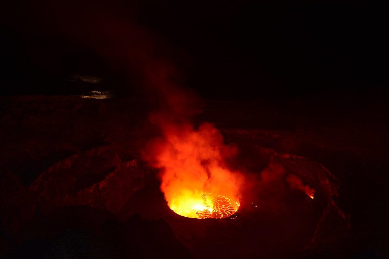
The consequences of the eruption of Mount Nyiragongo
Tens of thousands of people fled the neighboring nations as a result of this eruption because of the possibility of other eruptions.
Although the precise number of deaths linked to the lava has not been reported, the eruption caused a number of fatalities. Many have lost their houses and are now homeless.
In addition to destroying a trading center called “Sake,” where the locals used to do business and purchase food, the lava also damaged over 17 villages, including Majengo, Buhemi, and Katoyi.
Additionally, it had an impact on people’s businesses; the lava flow devastated schools, hospitals, and water supplies. Additionally, the government has closed several schools until the problem is resolved, and the destroyed hospitals pose a serious threat to the nation because they are the places where many people hurt by the lava flow must be taken, and there are other dangerous health facilities located farther away from Nyiragongo.
Numerous transportation infrastructures, like as the road connecting Goma and Bunagana, Uganda, were devastated as a result of the lava flow. The road was divided in two by the lava that resulted from the eruption, making it dangerous to travel to and from Uganda and Congo via the Banagana border.
The traffic collision that occurred when individuals were shifting in an attempt to get help and save their lives was the cause of death. Many youngsters were homeless after losing their parents.
Why Nyiragongo Remains One of the World’s Most Closely Watched Volcanoes
Given its status as one of the few volcanoes on Earth to maintain a persistent lava lake, Nyiragongo draws genuine scientific attention from volcanologists worldwide, alongside the tourism interest it generates from travelers hoping to witness this rare geological phenomenon safely from the crater rim.
Understanding the Volcano’s Position Within Virunga National Park
As part of the broader Virunga Conservation Area shared across the Democratic Republic of Congo, Rwanda, and Uganda, Nyiragongo sits within a landscape also famous for mountain gorilla trekking, meaning the region’s appeal spans both volcanic adventure and primate wildlife viewing. All in Africa Safaris can help you understand how this broader region fits into a Virunga itinerary.
What the Hiking Experience Involves for Travelers
Reaching the summit typically requires a demanding multi-hour trek followed by an overnight stay in cabins near the crater rim, rewarding hikers with the genuinely rare sight of an active lava lake glowing after dark.
Why Safety Monitoring Matters Before Planning a Visit
Given the volcano’s history of unpredictable eruptions, including the significant 2021 event, current safety advisories and park authority guidance should always be confirmed directly before planning any Nyiragongo-related travel, since conditions can change based on ongoing volcanic activity.
The Broader Regional Impact of Volcanic Activity Here
Beyond the immediate human toll, eruptions in this region affect transportation routes, cross-border trade, and regional stability given Nyiragongo’s proximity to both Goma and the Rwandan border, a context worth understanding for anyone following developments in the area.
Why Goma’s Location Makes It Particularly Vulnerable
Goma’s position just kilometers from the volcano’s base means the city has repeatedly faced direct impact from lava flows throughout Nyiragongo’s eruptive history, a geographic reality that shapes both local emergency planning and the broader region’s relationship with the volcano.
Comparing This Eruption to Nyiragongo’s 2002 Event
Nyiragongo’s history includes a significant prior eruption in 2002 that also sent lava through Goma, meaning the volcano’s pattern of periodic, disruptive activity reflects an ongoing geological reality rather than a single isolated incident.
What Recovery Looks Like for Affected Communities
Rebuilding damaged schools, hospitals, and transportation infrastructure following an eruption of this scale takes considerable time and resources, work that continues well beyond the immediate crisis and initial media attention.
Why Cross-Border Movement Increased During the Crisis
The scale of displacement into Rwanda during the eruption reflects both the severity of the immediate danger and the practical reality of the border’s proximity, offering the fastest route to safety for many affected Congolese residents.
How This Event Shapes Regional Travel Planning
Travelers considering the broader Virunga region should stay genuinely informed about current volcanic activity and any related travel advisories, since conditions around Nyiragongo can shift the practical logistics of a regional itinerary. All in Africa Safaris can provide current guidance on regional conditions before finalizing travel plans.
Why Scientific Monitoring Continues at Nyiragongo
Ongoing seismic and gas monitoring by regional volcanological institutes helps provide early warning ahead of future activity, work that plays a genuinely critical role in protecting the communities living in the volcano’s shadow.
What Makes Nyiragongo’s Lava Lake Scientifically Unusual
Persistent lava lakes are genuinely rare worldwide, and Nyiragongo’s status as one of the few volcanoes maintaining this feature makes it a significant site for understanding volcanic behavior beyond the immediate regional context.
The Human Cost Behind the Geological Story
Beyond the scientific and infrastructural details, the eruption’s genuine human toll, lost homes, displaced families, and disrupted livelihoods, remains the most significant and lasting consequence of this kind of natural disaster.
Why This History Matters for Understanding the Region Today
Nyiragongo’s eruptive pattern continues to shape how both local communities and regional authorities approach development, emergency preparedness, and land use decisions around Goma and the broader Virunga area.
Why the Region’s Fertile Volcanic Soil Complicates Settlement Patterns
Ironically, the same volcanic activity that poses periodic danger also creates the exceptionally fertile soil that has long drawn dense agricultural settlement around Goma, a genuine tension between natural hazard and economic livelihood that shapes the region’s development challenges.
How International Organizations Responded to the 2021 Crisis
Humanitarian agencies and regional governments mobilized emergency response efforts addressing displacement, medical needs, and infrastructure damage in the eruption’s aftermath, coordination that reflects the scale of disruption this kind of volcanic event causes across an entire urban area.
What Distinguishes Nyiragongo From Nearby Mount Nyamuragira
While Nyiragongo draws the most attention due to its proximity to Goma, its neighboring volcano Nyamuragira actually erupts more frequently, though with less direct impact on populated areas, a distinction worth understanding for anyone studying the region’s broader volcanic activity.
Planning Considerations If You’re Following This Region
Whether your interest is scientific, humanitarian, or travel-related, following updates from established regional monitoring institutions provides more reliable current information than secondhand reports, particularly given how quickly volcanic conditions can shift.
Why This Event Remains Relevant Years Later
The 2021 eruption’s lasting infrastructure damage and displacement effects continued shaping daily life around Goma long after the immediate crisis passed, a reminder that natural disasters of this scale carry consequences that extend well beyond the initial event itself.
Staying Informed About Virunga Region Developments
Given the region’s combination of volcanic activity and its status as a premier wildlife destination, staying current on both safety conditions and travel logistics matters for anyone planning to visit this remarkable but genuinely dynamic part of Central Africa. All in Africa Safaris can help you plan a Virunga-region itinerary with current, accurate information about conditions on the ground.