
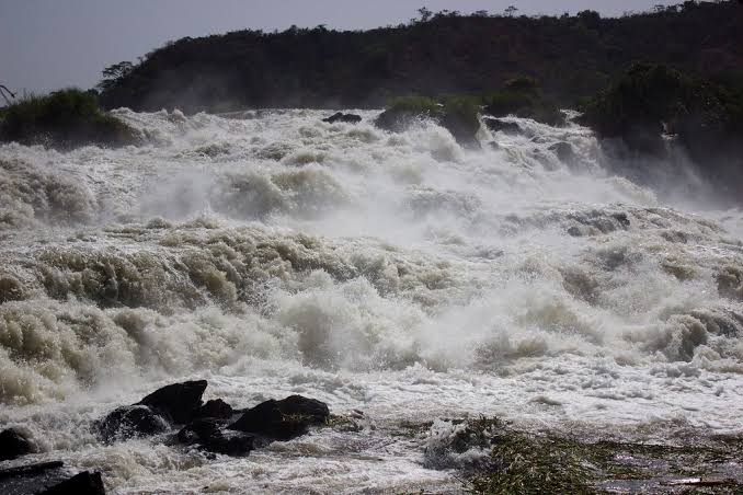
Karuma Falls: The Nile’s Wild Stretch Between Kampala and Gulu
Most travellers driving the Kampala-Gulu highway cross Karuma Falls without stopping, catching only a glimpse from the car window as the road bridges the Victoria Nile roughly 280 kilometres north of the capital. That’s a shame, because Karuma is one of the more accessible dramatic river stretches in Uganda, and one whose story now includes a genuinely significant piece of modern infrastructure alongside its natural rapids — the country’s largest power station, built directly at the falls and completed in 2024.
Key Highlights
- A stretch of Victoria Nile rapids roughly 280 km north of Kampala, on the Kampala-Gulu Highway in Kiryandongo District
- Site of the Karuma Hydroelectric Power Station, Uganda’s largest power installation, completed in September 2024 with 600 megawatts of capacity
- The station’s underground design was specifically engineered to preserve the visible surface rapids rather than submerging them
- Best viewed from the Karuma Bridge, built in 1963, with a new bridge planned to begin construction around August 2026
- Rapids most dramatic during the rainy seasons, roughly April-May and September-November
- A natural stopping point on the road between Kampala and both Murchison Falls National Park and Kidepo Valley National Park
A Waterfall That Became a Power Station, and Stayed a Waterfall
Karuma’s recent history is unusual for a natural landmark: rather than being flooded and erased by hydroelectric development, the way many dammed rivers lose their surface character entirely, engineers specifically designed the Karuma project as an underground facility to minimise disruption to the visible falls. The result, as of 2026, is a functioning 600-megawatt power station — Uganda’s largest single power-generating installation — operating essentially out of sight, while the Nile’s rapids continue to churn over the same fractured granite outcrops travellers have crossed for decades.
What Actually Changed and What Didn’t
Being honest about this matters more than romanticising it: the river’s absolute wildest flows have been moderated by the dam’s operation, and Karuma today isn’t quite the untouched natural spectacle it was before construction began in 2013. But the underground engineering approach genuinely worked as intended — the falls still roar with real power, especially during the rainy season peaks, and the visible rapids remain a legitimate reason to stop rather than a diminished afterthought. Travellers expecting an entirely wild, undeveloped river will notice the change; travellers simply wanting a dramatic Nile viewpoint on their route north will still find one.
Construction History Behind the Falls
The Karuma Hydroelectric Power Station was built by Sinohydro, a Chinese state-owned engineering firm, at a construction cost of roughly 1.7 billion US dollars. Ground broke in December 2013 with an original 60-month completion target; the project ultimately took closer to 114 months, becoming operational in September 2024 after considerable delay. Six turbines of 100 megawatts each now draw power from the Victoria Nile’s flow at this point, making Karuma the single largest contributor to Uganda’s national power grid and a genuinely significant piece of the country’s energy infrastructure, not just a local curiosity for passing travellers.
A Project With a Documented Labour History
The Karuma project has also been studied academically as a case in Sino-African labour relations, given the scale of Chinese engineering involvement and the workforce dynamics that came with a project of this size and duration. It’s a detail most travel guides skip entirely, but one that gives the site a genuinely interesting layer of context for travellers interested in more than just the view from the bridge.
Viewing the Falls Today
The most accessible vantage point remains the Karuma Bridge itself, built in 1963 and still carrying Kampala-Gulu Highway traffic across the river, offering an elevated view over the rapids and their granite outcrops without requiring any detour from the main route north. A new bridge is planned to begin construction around August 2026, expected to take roughly four years, so travellers passing through during that window should expect at least some construction activity alongside the existing crossing.
Best Time to See the Rapids at Their Most Dramatic
Water volume and visible surge peak during Uganda’s rainy seasons, roughly April to May and again September to November, when the Victoria Nile’s flow through Karuma’s narrowed granite channel is at its most turbulent. A dry-season crossing still shows genuine rapids, just with less dramatic volume than a wet-season stop.
What a Project This Size Means Downstream
A dam and power station of Karuma’s scale inevitably raises the question of what happens to the river further downstream, particularly given how close Karuma sits, relatively speaking, to Murchison Falls National Park and the famous Murchison Falls itself further along the same Victoria Nile. Large hydroelectric projects generally involve engineered flow-regulation designed to maintain a consistent downstream release rather than letting river volume swing wildly with the dam’s own operational needs, and Uganda’s environmental approval process for a project this size included assessment of exactly this kind of downstream impact before construction was approved.
An Honest Note on Ongoing Change
As with any major infrastructure project on a river this significant, it’s worth treating Karuma’s full long-term ecological picture as something still being understood rather than a fully settled question — the underground design successfully preserved the visible rapids, which was the primary tourism concern, but the broader hydrological and ecological effects of a 600-megawatt station operating continuously on this stretch of the Nile are the kind of thing environmental researchers will keep studying for years after commissioning, not something fully resolved the day the turbines switched on.
Photography and Practical Tips
The bridge itself offers the most straightforward vantage point, and photographs taken from it capture the rapids’ scale reasonably well, though the elevated angle means a telephoto or zoom lens helps pick out detail in the water’s texture over the granite outcrops below. Given this is a working highway bridge rather than a dedicated viewpoint, stopping safely matters more here than at almost any other roadside attraction in Uganda — pull well clear of the traffic lane and be mindful of the ongoing heavy vehicle traffic this route carries as a major national highway.
Combining Karuma With a Longer Journey
Because Karuma sits roughly midway on the long drive north from Kampala, it works naturally as a stretch-your-legs stop rather than requiring any dedicated detour or schedule adjustment. Drivers running the full Kampala-to-Murchison or Kampala-to-Kidepo route already budget for a midway break; positioning that break at Karuma rather than at a generic roadside stop turns dead travel time into a genuine, if brief, sightseeing moment.
Why Karuma Is Worth an Actual Stop, Not Just a Drive-Through
Karuma sits on the direct route between Kampala and two of Uganda’s major northern safari destinations, Murchison Falls National Park and Kidepo Valley National Park, which means most travellers heading north are already crossing it regardless. Building in a genuine five- or ten-minute stop, rather than treating it as pure transit, costs almost nothing in trip time and gives a legitimate, photogenic break partway through what’s otherwise a long drive.
Frequently Asked Questions
Is Karuma Falls still worth visiting given the hydroelectric dam?
Yes, with realistic expectations — the visible rapids remain genuinely impressive, especially in the rainy season, even though the site is no longer an entirely undeveloped natural feature. It’s best approached as a scenic stop on a longer journey rather than a dedicated destination in its own right.
Can I stop and get out to view the falls, or is it a drive-by only?
The Karuma Bridge itself offers roadside viewing, and travellers commonly stop briefly at or near the bridge for photos. Formal viewing infrastructure is limited compared to a dedicated national park attraction, so keep expectations modest for facilities.
How does Karuma compare to Murchison Falls itself?
Murchison Falls, further along the same river inside Murchison Falls National Park, is a far more dramatic and better-developed tourism attraction, with formal viewpoints, boat access and park infrastructure. Karuma is better understood as a worthwhile roadside stop on the way there, not a substitute for the main event, and most travellers naturally experience the two as a build-up: a genuine but brief highway glimpse of the Nile at Karuma, followed by the far more immersive boat-and-viewpoint experience once inside the park itself.
Will the new bridge construction disrupt travel through Karuma?
Some disruption is likely once construction begins around August 2026 given the roughly four-year build timeline, so travellers planning a route through Karuma during this period should build in some buffer time and expect possible traffic management at the crossing, and it’s worth checking current road advisories closer to your travel date rather than assuming the crossing will be exactly as smooth as it is today.
Recommended Safaris
Karuma sits directly on the route to two of Uganda’s major northern parks. Our Murchison Falls National Park and Kidepo Valley National Park pages both cover destinations reached via this same Kampala-Gulu route. Ready to build a Karuma Falls stop into your own northern Uganda itinerary, alongside either of these parks? Reach our team through our Book Now page and we’ll plan your route around it, with enough time built in for a genuine stop rather than a rushed drive-by.




No comment