Physical Features and Natural Landforms at Queen Elizabeth National Park
The first time I drove into Queen Elizabeth National Park, I thought the animals would be the main event.
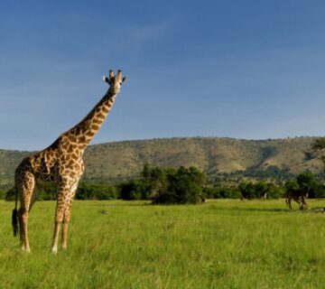
And they were incredible. Elephants crossing the road in front of us. Hippos snorting in the channel. Lions draped over fig tree branches like they owned the place. But what I didn’t expect—what I couldn’t have prepared for—was the land itself.
The park isn’t just a place where animals live. It’s a living museum of the earth’s geological history. The craters, the lakes, the channel, the escarpments—they all tell a story of a continent that’s still being shaped, still changing, still alive. And when you stand on the edge of an explosion crater, looking down at a lake that formed thousands of years ago, you realize that you’re not just a visitor—you’re a witness to something ancient and powerful.
A Park Born from the Rift
Queen Elizabeth National Park sits in the Western Rift Valley, part of the massive Great Rift Valley that runs all the way from the Middle East down to Mozambique. This is one of the most geologically active regions on the planet. The African continent is literally being pulled apart here, and the evidence is everywhere—in the steep escarpments, in the deep lakes, in the volcanoes that still smoke along the valley floor.
The park covers about 1,978 square kilometers. That’s roughly the size of the state of Delaware, but it feels much bigger because the land is so varied. The elevation ranges from about 910 meters at Lake Edward up to around 1,390 meters on the escarpment to the east. As you drive through the park, you climb and descend constantly, moving through different ecosystems, different temperatures, different worlds.
The western edge of the park is defined by the Rwenzori Mountains—the “Mountains of the Moon.” These peaks are snow-capped year-round, which is remarkable given that they sit almost on the equator. They rise to over 5,000 meters, and on clear days, you can see them from almost anywhere in the park. They’re a constant reminder of the tectonic forces that shaped this place.
The eastern boundary is marked by the Kichwamba Escarpment, a steep cliff that rises dramatically from the valley floor. The views from the top are breathtaking. You can see the entire park spread out below you—the plains, the forests, the lakes, and the channel cutting through the middle.
The Volcanic Craters
This is what makes Queen Elizabeth truly unique.
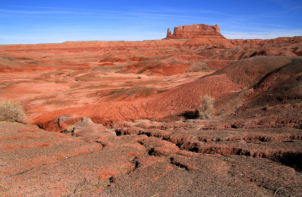
The park is dotted with explosion craters and crater lakes. These aren’t your typical volcanoes—the kind that pile up into dramatic cones. These are “explosion craters,” formed when rising magma met groundwater and caused massive steam explosions. The eruptions were violent, blasting ash and rock across the landscape and leaving behind deep depressions in the earth.
The Katwe-Kikorongo volcanic field covers about 180 square kilometers and contains around 80 of these craters. Some are filled with water, creating the crater lakes that dot the park. Others are dry, their floors covered in grass or forest. A few still release the occasional sulphurous smell, a reminder that the volcanic activity is only dormant, not extinct.
The most famous of these is Lake Katwe. It’s a shallow, salty crater lake that’s been mined for salt for centuries. Local communities have been extracting salt from its shores for generations, using traditional methods that haven’t changed much over time. The salt pans are fascinating to visit—you’ll see small mountains of salt drying in the sun, and you’ll meet the miners who still work there today.
The Bunyaruguru volcanic field lies to the southeast of the Kazinga Channel. Of the 152 craters in this field, only four are associated with lava—the rest were formed by gas explosions. Twenty-seven of these craters contain freshwater or saltwater lakes, creating a landscape that’s scattered with shimmering jewels of water.
Standing on the rim of one of these craters, you feel the weight of history. These weren’t gentle hills—they were violent explosions that reshaped the land and created the landscape we see today. The craters are silent now, but they tell a story of fire and force.
The Kazinga Channel
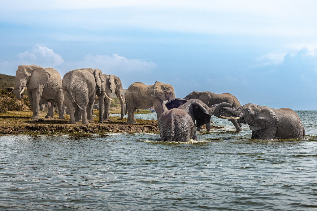
The Kazinga Channel is the park’s most defining feature. It’s a wide, natural waterway that stretches about 32 kilometers, connecting Lake George to the northeast with Lake Edward to the southwest. The channel roughly splits the park into northern and southern sectors.
The channel is alive with wildlife. Hippos float in the water like gray boulders, occasionally surfacing with a snort. Crocodiles bask on the banks, their mouths hanging open. Elephants and buffalo come down to drink, and the birdlife is extraordinary. Fish eagles, kingfishers, pelicans, herons—they’re all here.
I took a boat cruise on the channel on my first visit, and it remains one of my most vivid safari memories. The boat slipped through the water, and the hippos were so close that I could see the wrinkles around their eyes. The birds were everywhere, diving and calling. An elephant emerged from the forest and started drinking at the water’s edge, ignoring us completely.
The Kazinga Channel is also important ecologically. It’s the main water source for the park, and it creates a corridor for wildlife to move between the two lakes. Without the channel, the park would be a very different place.
The Two Lakes
Lake Edward is one of the Great Lakes of Africa. It lies in the western Rift Valley, straddling the border between Uganda and the Democratic Republic of Congo. It’s about 65 kilometers long and 38 kilometers wide, and its deepest part is a trench just 5 kilometers from the western shore.
The lake is fed by several rivers, but most of its water comes from Lake George via the Kazinga Channel. It’s a freshwater lake, though it’s slightly alkaline, which affects the species that can live there. The fishing communities along its shores depend on it for their livelihood.
Lake George is smaller and shallower—about 250 square kilometers with an average depth of just 2.4 meters. It’s fed by rivers flowing from the Rwenzori Mountains and the agricultural areas to the northeast. The lake’s northern shore is lined with dense papyrus swamp, which provides critical habitat for birds and other wildlife.
The wetlands around Lake George are so important that they’ve been designated as a Ramsar site. That means they’re recognized as wetlands of international importance. They filter water, provide breeding grounds for fish, and support an incredible diversity of birdlife.
The Soils and Drainage
The park’s geology has shaped its soils in fascinating ways. The volcanic origins mean the soils are rich in minerals, particularly potassium. These soils support the savannah grasslands and forests that cover much of the park.
The northern part of the park is dominated by alluvial soils—deposits left by rivers and lakes. These soils are deep and fertile, supporting dense vegetation. The southern part is different, with thinner soils that support drier, more open landscapes.
The drainage is also remarkable. Numerous rivers flow down from the Rwenzori Mountains and the escarpments, feeding into Lake Edward and Lake George. The Lake George catchment covers about 9,000 square kilometers and includes rivers like Nyamwamba, Rukoki, Mubuku, Rwimi, Dura, and Mpanga.
The water eventually flows out of the park through the River Semliki, which originates from the western part of Lake Edward. This river flows north into the DRC, carrying water that began its journey in the Rwenzori Mountains.
Ishasha: The Southern Wilderness
The Ishasha sector in the southern part of the park is completely different from the north. It’s drier and more open, with acacia woodlands and sweeping plains that feel remote and wild.
Ishasha is famous for its tree-climbing lions, but the landscape itself is worth the drive. The acacia trees dot the plains, providing shade for lions and other animals. The Ishasha River winds through the area, attracting wildlife to its banks.
Ishasha feels more remote than the northern sector. There are fewer lodges, fewer vehicles, and a deeper sense of solitude. You can sit for hours watching the plains, waiting for something to happen. And when it does—a lion appearing from the grass, an elephant emerging from the trees—the moment feels more significant.
The vegetation in Ishasha is dominated by acacia and candelabra trees. These are iconic African landscapes, the kind you’ve seen in documentaries and photographs. But they’re real here, and they’re breathtaking.
Thought
Queen Elizabeth National Park is a place of extraordinary geological diversity. The craters, the lakes, the channel, the escarpments—they all tell a story of a continent that’s still being shaped by powerful forces.
The animals are incredible. But the land is something else. It’s the foundation upon which everything else is built. And when you stand on the rim of an explosion crater, looking down at a lake that formed thousands of years ago, you realize that you’re not just a visitor. You’re a witness.