
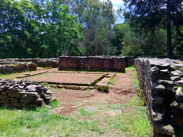
Engaruka Ruins: A Stone-Walled Settlement Near Lake Natron
Engaruka Ruins in Tanzania offer one of East Africa’s most fascinating archaeological experiences, revealing the remains of an ancient farming settlement built beneath the dramatic escarpments of the Great Rift Valley. Located along the road towards Lake Natron, Engaruka is famous for its stone walls, terraced fields and sophisticated systems for managing water.
Unlike the better-known archaeological discoveries at Olduvai Gorge, which focus on early human evolution, Engaruka tells the story of African communities who developed organised agricultural landscapes centuries ago.
Visitors can explore abandoned stone structures, learn about traditional farming techniques and enjoy beautiful views of the surrounding volcanic countryside.
For travellers exploring northern Tanzania, Engaruka offers an interesting cultural stop between Lake Manyara, Lake Natron and Ol Doinyo Lengai.
Where Are the Engaruka Ruins Located?
Engaruka lies in Monduli District, Arusha Region, within Tanzania’s northern Rift Valley.
The archaeological site stands beneath the steep escarpment overlooking the Engaruka Basin.
It is accessible from the road connecting Mto wa Mbu with Lake Natron.
Quick Facts About Engaruka
| Feature | Description |
|---|---|
| Country | Tanzania |
| Region | Arusha |
| District | Monduli |
| Main attraction | Ancient stone-walled settlement |
| Archaeological period | Primarily Late Iron Age |
| Main farming development | Around the 15th–18th centuries |
| Famous features | Stone terraces and irrigation channels |
| Nearby destination | Lake Natron |
| Recommended visit | 1½–3 hours |
| Best experience | Guided archaeological walk |
Why Are Engaruka Ruins Important?
Engaruka preserves evidence of an extensive farming landscape developed by communities living in a difficult environment.
The settlement contains stone terraces, field boundaries, irrigation channels and residential structures.
These remains demonstrate impressive knowledge of agriculture, soil management and water distribution.
An Important African Achievement
Engaruka is significant because its agricultural system developed through local knowledge and adaptation.
Its inhabitants managed water and cultivated land beneath an escarpment where rainfall could be unreliable.
The site challenges assumptions that complex farming systems in East Africa required outside influence.
The History of Engaruka
The archaeological landscape developed over several centuries.
Although some older structures indicate earlier occupation, the best-known farming settlement flourished during the later Iron Age.
Research identifies major agricultural developments beginning around the fifteenth century.
When Was Engaruka Occupied?
The settlement expanded during the following centuries as farming communities developed extensive terraced fields.
Different parts of the landscape may have been occupied at different times.
By the eighteenth or early nineteenth century, much of the principal agricultural settlement had been abandoned.
The precise sequence remains an important subject of archaeological research.
Who Built the Stone-Walled Settlement?
One of Engaruka’s greatest mysteries concerns the identity of its builders.
Researchers have suggested possible connections with communities ancestral to the Iraqw or Sonjo peoples.
However, no single explanation has been conclusively established.
What Archaeologists Know
The inhabitants possessed knowledge of stone construction, farming and water management.
They developed permanent or long-lasting agricultural settlements.
Their work required considerable organisation.
The remains provide evidence of skilled African farming communities, even though their precise identity remains debated.
Exploring Engaruka’s Stone Walls
The most noticeable archaeological features are extensive arrangements of stones spread across the landscape.
Some form terraces, while others mark former fields or residential areas.
Why Were Stone Walls Built?
The walls served several purposes.
They helped retain soil on sloping ground.
Some controlled water movement and trapped fertile sediment.
Others marked cultivated plots or supported settlement structures.
Their arrangement reveals careful planning and sustained agricultural activity.
The Ancient Irrigation System
Engaruka is particularly famous for its sophisticated irrigation and water-management system.
The settlement relied partly on water flowing from the surrounding highlands.
Channels directed water towards agricultural areas, while stone structures helped manage soil and sediment.
How Did the System Work?
Water moved through constructed channels towards cultivated plots.
Farmers used stone boundaries and retaining walls to control its distribution.
Some structures captured sediment, gradually creating deeper and more productive soils.
Recent archaeological research has demonstrated that Engaruka’s farmers combined irrigation with careful management of seasonal flooding.
Understanding the Agricultural Terraces
Terraces are among the most impressive surviving features.
They transformed uneven ground into areas suitable for cultivation.
Why Terracing Was Useful
| Farming challenge | Ancient solution |
|---|---|
| Sloping terrain | Stone-supported terraces |
| Soil erosion | Retaining walls |
| Irregular rainfall | Water-management channels |
| Sediment movement | Stone check dams |
| Limited fertile soil | Capturing deposited sediment |
These techniques demonstrate practical understanding of the surrounding environment.
What Crops Were Grown at Engaruka?
Archaeologists have investigated the settlement’s agricultural economy.
The farming system probably supported cereal production and other crops suited to regional conditions.
However, not every crop cultivated by Engaruka’s inhabitants can be identified with certainty.
Farming and Livestock
Evidence suggests that agriculture formed an important part of the local economy.
Livestock keeping may also have contributed to food production and soil fertility.
The relationship between farming and pastoral activities remains an interesting research topic.
Why Was Engaruka Abandoned?
The abandonment of Engaruka has attracted considerable academic discussion.
Earlier explanations often focused on declining water supplies, environmental deterioration or conflict.
More recent research suggests a more complicated history.
Possible Reasons
Changes in rainfall may have affected farming.
Population movements could have altered settlement patterns.
Regional trade networks also changed over time.
Some communities may have adopted different livelihoods.
Researchers have not established one definitive cause, and abandonment probably involved several interacting factors.
Walking Through the Archaeological Site
A guided walk is the best way to appreciate Engaruka’s historic landscape.
Without explanation, some structures resemble ordinary piles of stones.
A knowledgeable guide can help visitors recognise ancient field boundaries, terraces and possible residential areas.
What Happens During a Visit?
The walk usually begins with an introduction to the settlement’s history.
Visitors then explore accessible sections of the ruins.
Guides explain the stonework and agricultural techniques.
The surrounding escarpment provides an impressive scenic background.
The Great Rift Valley Landscape
Engaruka lies within one of Africa’s most remarkable geological regions.
The surrounding landscape contains steep escarpments, dry plains and volcanic formations.
Why the Location Matters
The escarpment influenced water movement.
Seasonal flows transported sediment towards the basin.
Ancient farmers developed techniques suited to these local conditions.
Understanding the landscape helps explain how Engaruka’s agricultural system functioned.
Visiting Engaruka From Lake Natron
Engaruka is conveniently located along routes connecting Mto wa Mbu with Lake Natron.
Travellers can include the ruins in an overland expedition through northern Tanzania.
Nearby Attractions
| Destination | Main attraction |
|---|---|
| Lake Natron | Flamingos and alkaline waters |
| Ol Doinyo Lengai | Active volcano |
| Engaresero | Waterfall and volcanic landscapes |
| Mto wa Mbu | Cultural experiences |
| Lake Manyara | Wildlife and birdwatching |
These destinations provide opportunities to combine archaeology, geology and wildlife.
Best Time to Visit Engaruka
Engaruka can be visited throughout the year.
However, relatively dry conditions make walking and road travel easier.
June to October and January to March are generally convenient periods.
Seasonal Visiting Conditions
| Period | General conditions |
|---|---|
| January–March | Often hot and relatively dry |
| April–May | Increased rainfall |
| June–October | Generally favourable walking conditions |
| November–December | Variable rainfall |
The exposed landscape can become extremely hot during midday.
Morning visits are usually more comfortable.
How to Reach Engaruka Ruins
Most visitors approach Engaruka from Arusha or Mto wa Mbu.
The route continues north through the Rift Valley towards Lake Natron.
Some road sections are rough and may become difficult during rainfall.
Transport Advice
A reliable four-wheel-drive vehicle is recommended for longer Lake Natron itineraries.
Travel with an experienced local driver.
Carry drinking water and sun protection.
Confirm road conditions before departing.
Entrance Fees and Local Guides
Visiting arrangements may include site admission and local guiding charges.
Fees can change, and not all services have consistently published tariffs.
Visitor Planning Guide
| Item | Recommendation |
|---|---|
| Admission | Confirm locally |
| Guiding | Arrange an authorised guide |
| Visit duration | 1½–3 hours |
| Footwear | Closed walking shoes |
| Drinking water | Carry sufficient supplies |
| Photography | Follow guide instructions |
Confirm the total cost before beginning the tour.
Photography at Engaruka
Engaruka provides excellent opportunities for cultural and landscape photography.
The stone structures create interesting patterns against the escarpment.
Photography Tips
Use morning light to highlight the terraces.
Capture wider views showing the relationship between the settlement and surrounding hills.
Avoid climbing fragile walls.
Request permission before photographing local residents.
Responsible Archaeological Tourism
Engaruka contains valuable historical evidence that must be protected.
Visitors should remain on approved paths.
Never remove stones or archaeological objects.
Avoid damaging walls or entering restricted excavation areas.
Support knowledgeable local guides and community tourism initiatives.
Responsible travel helps preserve the settlement for future research.
Suggested Half-Day Engaruka Visit
Begin with an early departure from nearby accommodation.
Meet your local guide for an introduction to the site.
Walk through accessible sections of the settlement and examine the ancient terraces.
Spend time photographing the landscape.
Continue towards Lake Natron or return to Mto wa Mbu.
Travellers should allow extra time when road conditions are difficult.
Why Engaruka Ruins Are Worth Visiting
Engaruka Ruins provide a fascinating opportunity to discover an important chapter of East African agricultural history.
The settlement’s stone walls, irrigation channels and terraced fields demonstrate the knowledge and ingenuity of communities who adapted to the challenging Rift Valley environment.
Its archaeological mysteries make the experience even more interesting.
For travellers visiting Lake Natron or Ol Doinyo Lengai, Engaruka offers a meaningful cultural stop that adds human history to northern Tanzania’s dramatic volcanic landscapes.







No comment