
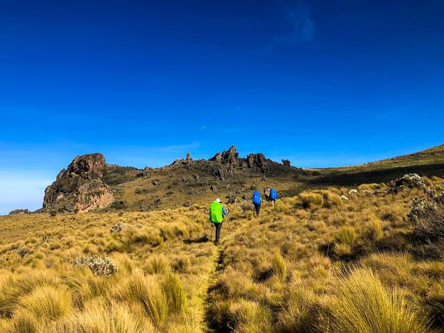
Mount Elgon Sasa, Sipi and Piswa Trails Compared
Mount Elgon Sasa, Sipi and Piswa trails offer three different ways to explore one of Uganda’s most impressive mountain landscapes. Located along the Uganda–Kenya border, Mount Elgon is an ancient volcanic mountain known for its extensive caldera, montane forests, waterfalls and high-altitude vegetation.
The mountain’s highest point, Wagagai Peak, stands at approximately 4,321 metres above sea level. Unlike technical mountaineering destinations, the main Ugandan trekking routes generally involve hiking rather than glacier climbing.
However, choosing the right route is important. The Sasa Trail is shorter but steeper, the Sipi Trail offers varied scenery, and the Piswa Trail provides a longer, more gradual approach.
This comparison will help you understand the differences and choose a Mount Elgon trekking experience that matches your fitness, interests and available time.
Understanding Mount Elgon’s Main Trekking Trails
Mount Elgon National Park protects extensive mountain habitats in eastern Uganda.
The mountain can be explored through day walks and longer trekking expeditions.
Three established Ugandan routes lead towards its higher elevations.
Sasa, Sipi and Piswa Trails at a Glance
| Feature | Sasa Trail | Sipi Trail | Piswa Trail |
|---|---|---|---|
| Starting point | Budadiri | Kapkwai | Kapkwata |
| Typical duration | 4 days | 4–6 days | Around 7 days |
| Starting elevation | About 1,250 m | About 2,050 m | Higher northern approach |
| Main characteristic | Short and steep | Varied scenery | Gradual ascent |
| Main attraction | Direct approach to Wagagai | Forests, caves and mountain scenery | Forests, plains views and caldera |
| Physical challenge | Steep initial climb | Longer walking sections | Longer overall trek |
Durations depend on the itinerary and trekking conditions.
Sasa Trail: The Shortest Route to Wagagai
The Sasa Trail begins at Budadiri on Mount Elgon’s western side.
It is traditionally considered the shortest established approach to Wagagai Peak.
However, the shorter distance does not make it the easiest route.
What Makes the Sasa Trail Challenging?
The trail begins at a relatively low elevation.
Trekkers therefore face substantial climbing during the early stages.
The first day can be particularly demanding because of the elevation gain.
The route passes through cultivated land, forest and higher mountain vegetation.
Main Attractions
The Sasa Trail provides opportunities to experience:
Local farming landscapes.
Montane forest.
Bamboo vegetation.
High-altitude moorland.
Jackson’s Pool.
Views towards Wagagai Peak.
The scenery changes considerably as you climb.
Who Should Choose the Sasa Trail?
The route is suitable for physically prepared hikers who want a relatively short expedition.
Previous hiking experience is useful.
Travellers with limited trekking experience should consider whether the steep ascent is appropriate.
Sipi Trail: A Scenic Mountain Approach
The Sipi Trail begins around the Kapkwai Forest Exploration Centre, near the Sipi area.
Its starting elevation is approximately 2,050 metres.
The route passes through forested landscapes before continuing towards higher mountain terrain.
What Makes the Sipi Trail Attractive?
The Sipi Trail offers a varied hiking experience.
Trekkers may pass through forest, bamboo vegetation, valleys and open mountain landscapes.
The route is associated with sites such as Tutum Cave.
Main Attractions
| Attraction | What to expect |
|---|---|
| Kapkwai Forest | Montane vegetation |
| Tutum Cave | Geological and natural interest |
| Mountain valleys | Changing landscapes |
| Higher moorland | Open views |
| Wagagai approach | Summit trekking opportunity |
The trail becomes more demanding as elevation increases.
Who Should Choose the Sipi Trail?
The Sipi Trail is suitable for travellers who enjoy longer walking days and varied scenery.
It can also appeal to visitors who want to combine mountain trekking with activities around Sipi Falls.
However, the waterfall walks and the summit route are separate experiences.
Piswa Trail: The Longer, Gradual Route
The Piswa Trail begins near Kapkwata on Mount Elgon’s northern side.
It is generally regarded as a longer and more gradual approach than the Sasa Trail.
Some itineraries take approximately seven days.
What Makes Piswa Different?
The trail passes through plantation areas, forest and higher mountain vegetation.
It offers views towards the Karamoja plains and parts of western Kenya when conditions are clear.
The route can also provide access towards the mountain’s caldera and hot spring areas.
Main Attractions
Piswa is known for:
Forest landscapes.
Podocarpus vegetation.
Mountain wildlife habitats.
Views towards Karamoja.
High-altitude moorland.
Caldera scenery.
Hot spring areas.
Wildlife sightings are possible but never guaranteed.
Who Should Choose the Piswa Trail?
Piswa suits travellers who have more time and prefer a gradual approach.
However, the longer duration still requires good fitness.
Gradual terrain does not eliminate altitude or weather challenges.
Which Mount Elgon Trail Is Easiest?
There is no completely easy route to Mount Elgon’s higher peaks.
Each trail presents different challenges.
Sasa has a particularly demanding initial ascent.
Sipi involves longer trekking sections and changing terrain.
Piswa is generally more gradual but requires additional days.
Comparing Difficulty
| Factor | Sasa | Sipi | Piswa |
|---|---|---|---|
| Initial ascent | Steep | More gradual | Generally gradual |
| Total trekking time | Shorter | Moderate | Longer |
| Altitude exposure | Significant | Significant | Significant |
| Muddy terrain | Possible | Possible | Possible |
| Fitness requirement | High | High | High |
| Best for limited time | Yes | Sometimes | Less suitable |
A longer itinerary may provide more time to adjust to elevation.
However, altitude planning depends on the actual overnight schedule.
Reaching Wagagai Peak
Wagagai is Mount Elgon’s highest point.
At approximately 4,321 metres, it is a demanding high-altitude hiking destination.
The summit approach generally does not require the technical glacier equipment associated with mountains such as the Rwenzori.
However, weather, altitude and difficult walking terrain remain important considerations.
What to Expect Near the Summit
The upper mountain includes open moorland and volcanic landscapes.
Temperatures can become cold.
Cloud and mist may reduce visibility.
Strong winds and rainfall are also possible.
A successful summit depends on fitness, weather and safe trekking conditions.
Mount Elgon’s Volcanic Caldera
One of Mount Elgon’s most distinctive features is its extensive volcanic caldera.
The mountain developed through ancient volcanic activity.
Today, the upper landscape contains valleys, ridges and other geological formations.
Some longer trekking itineraries include caldera exploration.
However, the exact route depends on the chosen trail and available time.
Wildlife and Vegetation Along the Trails
Mount Elgon contains several vegetation zones.
Lower elevations support forest habitats.
Higher sections include bamboo, heath and moorland vegetation.
What You May Encounter
| Vegetation zone | General characteristics |
|---|---|
| Montane forest | Tall trees and forest wildlife |
| Bamboo zone | Dense bamboo vegetation |
| Heath zone | Shrubs and giant heather |
| Moorland | Open high-altitude vegetation |
| Upper mountain | Rocky and volcanic landscapes |
Birdwatching opportunities exist along the lower forest trails.
Wildlife should be observed quietly and from a safe distance.
Best Time to Hike Mount Elgon
Mount Elgon receives rainfall during different periods of the year.
Drier conditions generally make trekking more comfortable.
Seasonal Conditions
| Period | General weather | Trekking advice |
|---|---|---|
| December–February | Often relatively dry | Popular hiking period |
| March–May | Common rainy season | Expect muddy trails |
| June–August | Often relatively dry | Good trekking opportunities |
| September–November | Common rainy season | Prepare for wet conditions |
Rainfall can occur throughout the year.
Always carry waterproof clothing.
How Many Days Do You Need?
The number of days depends on your chosen trail and whether you want to reach Wagagai.
Suggested Trekking Durations
| Experience | Suggested duration |
|---|---|
| Short forest walk | Half day to 1 day |
| Sipi area exploration | 1–2 days |
| Sasa summit itinerary | Around 4 days |
| Sipi summit itinerary | 4–6 days |
| Piswa trekking itinerary | Around 7 days |
These are general planning estimates.
Confirm the exact itinerary with your mountain operator.
What to Pack for Mount Elgon
Mountain weather changes quickly.
Suitable clothing and equipment are essential.
Essential Packing List
Waterproof hiking boots.
Rain jacket.
Waterproof trousers.
Warm fleece.
Thermal clothing.
Comfortable trekking trousers.
Gloves.
Headtorch.
Trekking poles.
Water bottles.
Personal medication.
Sleeping equipment as advised.
Your operator should explain which items are provided.
Guides, Porters and Trekking Arrangements
Longer Mount Elgon treks should be organised through authorised arrangements.
Guides help with navigation, route conditions and safety.
Porters may assist with carrying camping supplies.
The Uganda Wildlife Authority regulates activities within the national park.
Before booking, confirm park fees, guiding arrangements and equipment requirements.
How Much Does Mount Elgon Trekking Cost?
Costs depend on the route, number of days and services included.
A shorter Sasa itinerary may involve fewer days of food and accommodation than a longer Piswa trek.
However, prices depend on the complete package.
Main Cost Components
| Expense | What it covers |
|---|---|
| Park entry | Access to the protected area |
| Guide | Trekking supervision |
| Porter | Equipment transport |
| Camping | Overnight arrangements |
| Meals | Food during the expedition |
| Transport | Transfers to trailheads |
| Equipment | Rental where necessary |
Request a detailed quotation before booking.
Combining Mount Elgon With Sipi Falls
Sipi Falls is one of eastern Uganda’s popular attractions.
Visitors can arrange waterfall walks, coffee experiences and other countryside activities.
A Mount Elgon trek can be combined with a stay around Sipi.
However, summit trekking and waterfall sightseeing require different levels of preparation.
Allow sufficient recovery time after a demanding hike.
Which Trail Should You Choose?
Your choice should depend on time, fitness and personal interests.
Choose Sasa if you want the shorter established route and can manage steep climbing.
Choose Sipi if you enjoy varied scenery and want to explore the mountain from the Kapkwai side.
Choose Piswa if you have more time and prefer a longer, generally gradual approach.
Whichever route you choose, prepare for altitude, changing weather and several days of walking.
Mount Elgon’s Sasa, Sipi and Piswa trails offer different trekking experiences within Uganda’s eastern highlands.
Sasa is shorter but steeper, Sipi provides varied forest and mountain scenery, and Piswa offers a longer approach with extensive views.
All three require preparation, appropriate equipment and experienced guiding.
By comparing their difficulty, duration and attractions, you can choose a Mount Elgon route that suits your travel plans and hiking ability.


No comment